All the reasons why the 2025 hurricane season will be remembered as downright 'weird'
Published in News & Features
FORT LAUDERDALE, Fla. — The 2025 Atlantic hurricane season is just about over, with no tropical systems likely to develop before its official close on Nov. 30.
It might seem like a fortunate flop — only five hurricanes, when most forecasts back in spring called for eight or nine.
It was actually “pretty hopping,” said University of Miami meteorologist Brian McNoldy. It was also “weird” said Colorado State hurricane expert Phil Klotzbach.
“Overall it’s a strange season to categorize,” said Klotzbach. We had fewer than average hurricanes, about 70% of normal, but far more days with major hurricanes, about 150% above average, he said.
Though the season only produced five hurricanes, four of them were major hurricanes of Category 3 or higher, and three were Category 5 storms — highly unusual. The only other time that has happened in recorded history was in 2005 with Hurricanes Emily, Katrina, Rita and Wilma.
It was the first year since 2015 without a hurricane hitting the U.S., and the first time since 2010 with an “above normal” season with no landfalls.
There was also an odd lull at the traditional peak of the season from mid-August to the end of September.
And through some very lucky circumstances, nearly every storm in the Atlantic arced north away from land.
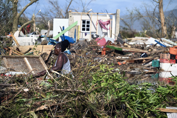
Tragically, Hurricane Melissa, the last storm of the year, was also the strongest and deadliest, with winds of 185 mph and impacts that caused more than 90 fatalities in the Caribbean.
Stormy expectations
Expectations were high (as in rough) leading into the season. According to June outlooks from Colorado State’s tropical weather center, the 2025 season was supposed to be above average due to unusually warm sea surface temperatures in the Atlantic, and the fact that El Niño, which can hamper storms via wind shear, had dissipated.
Forecasters predicted that the 2025 season would generate:
—17 named storms (there have been 13).
—Nine hurricanes (there have been five — Andrea, Chantal, Erin, Gabrielle and Melissa).
Protection forces and dumb luck
Fortunately, only one named storm, Chantal, made landfall in the U.S., when it rolled into South Carolina.
Powerful steering forces and a bit of “dumb luck” kept storms away.
The Bermuda High, a semi-permanent high pressure system that sits over the Atlantic and has the power to block hurricanes northward turns, was generally weak, so every storm traveling across the Atlantic took sharp turns to the north, away from land.
There were other fortuitous factors. Klozbach said that a low pressure area parked over the east coast for five or six weeks this summer blocked storms from approaching the U.S. It also produced a lot of win shear that would have hampered any storm that had broken through.
The wild cards were Hurricanes Humberto and Imelda. The two storms paralleled each other as they headed toward the U.S., with Imelda making a B-line for the Carolinas. But about a day before impact, the storm made a sudden dogleg out to the Atlantic, sucked away from land by Humberto’s winds.
“Imelda was a very close call,” said Klozbach. “That was really dumb luck that we had Humberto right there to basically tug Imelda out to sea.”
If Humberto hadn’t been there, “Imelda would have been a really bad rainmaker for the Carolinas,” Klozbach said.
Lulls-ville
During what is normally the peak of hurricane season — from mid-August to late September — there was a lull in tropical activity. Klotzbach said that during the lull there were pronounced high-altitude, low-pressure systems — called tropical upper-tropospheric troughs — that sent wind shear across the Atlantic, nipping storms in the bud.
Hurricane Melissa, which would break records with sustained wind speeds of 185 mph, formed as a tropical storm on Oct. 21. It traveled over Caribbean waters with heat content that was “through the roof,” said Klotzbach.
That deep hot water was why Melissa was able to remain a Category 5 for some 36 hours — much longer than average.
This year’s hurricanes Humberto and Erin, which never made landfall, each had a six-hour stretch of Cat 5 power. 2005’s Katrina managed 18 hours.
“It’s rare to have no hurricanes in the Caribbean through mid October, and then fire off a Cat 5 — every year is weird, but I feel like in these last two years I’ve used the words weird and strange a lot,” said Klozbach.
The future
The season is essentially over. “I’d be very surprised if we got anything substantial at this point,” said Klozbach. Given the above average Accumulated Cyclone Energy, the National Oceanic and Atmospheric Administration will refer to 2025 as an “above normal” season.
As for next year, NOAA suspects the current weak La Niña will be around through the winter and return to neutral by spring.
“The last El Niño was 2023 to 2024, so there’s a possibility of getting one,” said Klozbach.
An El Niño normally brings shear, which is bad for hurricanes. That said, 2023 was an El Niño year and was still very very busy, said Klotzbach. “That’s because the Atlantic was so dang hot,” he said.
©2025 South Florida Sun Sentinel. Visit at sun-sentinel.com. Distributed by Tribune Content Agency, LLC.


Comments