Category 4 Hurricane Melissa slowly moving toward Jamaica, Cuba and the Bahamas
Published in News & Features
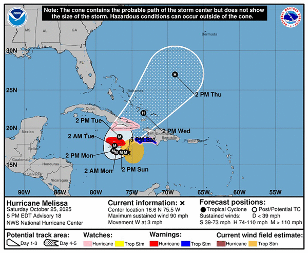
Hurricane Melissa strengthened into a 140 mph Category 4 storm early Sunday morning and continues on its path toward Jamaica, Cuba and the Bahamas.
“Tropical storm conditions are likely occurring in Jamaica, with hurricane conditions expected to begin by Monday,” the National Hurricane Center said in its 11 a.m. Sunday advisory.
As of the 11 a.m. advisory...
Where’s Melissa and where’s Melissa going?: Melissa is about 110 miles south of Kingston, Jamaica, and 280 miles south-southwest of Guantánamo, Cuba. As it moves directly west, its speed has slowed back down to 3 mph after being at 5 mph at the 8 a.m. advisory.
“A slow westward motion is expected (Sunday), followed by a turn to the north and northeast on Monday and Tuesday,” the hurricane center said. “On the forecast track, the core of Melissa is expected to move near or over Jamaica through Tuesday, across southeastern Cuba Tuesday night, and across the southeastern Bahamas on Wednesday.”
Melissa’s size and strength: Melissa’s bringing 140 mph maximum sustained winds, making it a Category 4 storm. Hurricane force winds blow up 25 miles from the storm’s center, and tropical storm force winds blow another 150 miles from Melissa’s center.
“Additional intensification is forecast over the next day or so, followed by fluctuations in intensity,” the hurricane center said. “Melissa is expected to be a powerful major hurricane when making landfall in Jamaica Monday night or Tuesday morning and southeastern Cuba late Tuesday.”
Watches and warnings about Melissa: These remain as they’ve been since Saturday afternoon.
Jamaica is under a hurricane warning.
Hurricane watches are in effect for the Cuban provinces of Granma, Guantánamo, Holguín and Santiago de Cuba. Haiti’s southwest peninsula, from the border with the Dominican Republic to Port-Au-Prince, is under a hurricane watch and tropical storm warning, meaning they can expect tropical storm conditions within the next 36 hours.
On Saturday, the South and Grand’Anse regions of Haiti were both upgraded to red alerts by the National Disaster Risk Management System. Haitians were warned the intensification of Melissa had increased the risks of flash floods and landslides. Haitians were asked to remain home, or to move to higher ground if they lived in a flood-prone area. They also were warned to “not cross rising water,” by any means.
Melissa’s effects: If you’re looking for good news in the update for any part of the Caribbean, “the potential for hurricane conditions in the watch area in Haiti have diminished for (Sunday).”
But tropical storm winds are still expected Sunday in Haiti, and hurricane winds remain possible Tuesday. Eastern Cuba could get hurricane force winds Tuesday and Wednesday.
As a slow-moving storm, Melissa is expected to dump 15 to 30 inches of rain on Jamaica and the southern part of Hispaniola, with some areas getting 40 inches. And the showers aren’t expected to stop on Wednesday.
“Catastrophic flash flooding and landslides are probable across portions of southern Hispaniola and Jamaica,” the hurricane center said.
The same flooding and landslides are expected in Eastern Cuba, which is forecast to be drenched by 10 to 15 inches of rain in most places and up to 20 inches in spots by Wednesday.
Rain measuring 4 to 8 inches is expected to fall on the Bahamas and 1 to 4 inches on Turks and Caicos Tuesday into Wednesday.
The wind and rain means, “life-threatening storm surge is likely along the south coast of Jamaica late Monday through Tuesday morning. Peak storm surge heights could reach 9 to 13 feet above ground level” near Melissa’s landfall area and east of it.
“This storm surge will be accompanied by large and destructive waves,” the hurricane center said. “There is a potential for significant storm surge along the southeast coast of Cuba late Tuesday or Wednesday.”
_____
©2025 Miami Herald. Visit miamiherald.com. Distributed by Tribune Content Agency, LLC.


Comments