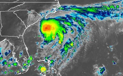
Chantal wasn't a hurricane but still caused big damage in NC. Here's why
Published in News & Features
Tropical depressions may sound minor compared to hurricanes, but both weather events can cause major damage.
Chantal made landfall as a tropical storm in South Carolina and was later downgraded to a tropical depression.
The depression brought heavy rain to North Carolina late Sunday and early Monday, flooding parts of Orange, Durham and Chatham counties.
Chantal brought greater rainfall in predicted areas, said Tom Green, a Raleigh meteorologist at the National Weather Service.
The rain increased water levels in the Haw River, which is measured by river gauges. These gauges help determine whether the river is safe to enter or at risk of flooding.
The maximum safe water levels for canoeing and other paddling activities is 4 to 6 feet in most areas, according to the Haw River Trail website.
Minor flooding occurred Sunday when river levels reached 18 feet and worsened as levels peaked at 32.5 feet early Monday.
The flooding prompted a partial closure of Interstate 40, a state of emergency in Orange County and evacuations in Chapel Hill and Durham.
Storms like Chantal are categorized based on wind speed because that helps predict potential property damage. Danger from other potentially deadly hazards, including flooding, storm surges and tornadoes, is not considered.
What is the difference between a hurricane and a tropical depression?
Hurricanes and tropical depressions are types of tropical cyclones, a broader term that covers all rotating storm systems that form in warm tropical waters.
Cyclones are typically 120 to 300 miles in diameter, bring strong winds and are one of the most destructive natural weather events.
Different regions of the world call tropical cyclones different things.
For example, hurricanes in the United States are equivalent to typhoons in China. The naming differences are rooted in tradition and culture.
These storms are categorized based on their maximum sustained wind speed, Green said.
—Tropical depressions have winds of 38 mph or less.
—Tropical storms have winds of 40 to 73 mph.
—Hurricanes have winds of 74 mph or higher.
Hurricanes are ranked 1-5 using the Saffir-Simpson hurricane wind scale, with category 5 being the highest. This scale is also based on maximum sustained wind speed. Hurricanes in categories 3-5 are considered major due to substantial risk of devastating damage and death.
—Category 1 — 74 to 95 mph
—Category 2 — 96 to 110 mph
—Category 3 — 111 to 129 mph
—Category 4 — 130 to 156 mph
—Category 5 — 157 mph or higher
North Carolina is most likely to experience cyclones from June 1 to Nov. 30, which is the Atlantic hurricane season.
The National Weather Service predicts that the 2025 Atlantic hurricane season will have more storm activity than normal. Many factors influence this prediction, including warmer than average ocean temperatures. The NWS is 70% confident in these predictions
—13 to 19 total storms with winds of 39 mph or higher
—6 to 10 total hurricanes
—3 to 5 major hurricanes
How can tropical depressions cause major flooding?
Like all cyclones, tropical depressions cause heavy rain that can trigger flooding. The amount of rain an area gets depends on how long the storm stays in that area.
When storms reach land they lose access to the warm water that fuels them, slowing them down.
Though this ultimately weakens the storm, it causes prolonged rain in specific areas. This precipitation joins nearby lakes, rivers and other bodies of water, raising their levels.
Tropical depressions tend to quickly increase water levels, causing bodies of water to overflow and flood nearby land.
For more information about tropical depressions, hurricanes and other cyclones, go to www.weather.gov/rah/
_____
©2025 Raleigh News & Observer. Visit newsobserver.com. Distributed by Tribune Content Agency, LLC.


Comments