Hurricane Helene eye wall coming ashore as major Category 4 storm with 140 mph winds
Published in News & Features


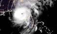

ORLANDO, Fla. — Hurricane Helene intensified into a major Category 4 hurricane with 140 mph winds with its eye wall beginning to come ashore Thursday night, bringing devastating winds and storm surge to Florida’s Big Bend, according to the National Hurricane Center.
“Helene is producing catastrophic winds that will be spreading onshore in the Florida Big Bend region during the next few hours,” the NHC posted in a 10 p.m. Eastern time update. “This is an extremely dangerous and life-threatening situation. Persons should not leave their shelters and remain in place through the passage of these life-threatening conditions.”
In a special 6:20 p.m. update, the NHC said an NOAA Hurricane Hunter aircraft found that the maximum sustained winds had increased to 130 mph, making it a Category 4 hurricane. That took less than four hours since the NHC found it had grown into a Category 3 major hurricane, picking up energy from the hot waters of the Gulf of Mexico.
By 10 p.m., it had grown to 140 mph sustained winds and was located about 65 miles west-northwest of Cedar Key and 65 miles south of Tallahassee as it moved north-northeast at 24 mph.
“A catastrophic and deadly storm surge is likely along portions of the Florida Big Bend coast, where inundation could reach as high as 20 feet above ground level, along with destructive waves,” said NHC senior hurricane specialist Jack Beven. “There is also a danger of life-threatening storm surge along the remainder of the west coast of the Florida Peninsula. Residents in those areas should follow advice given by local officials and evacuate if told to do so.”
An NOAA National Ocean Service tide gauge located at Clearwater Beach recently reported a water level of 6.18 feet above mean higher high water. A National Ocean Service tide gauge at Cedar Key is reporting a water level 5.76 feet above mean higher high water.
At 8 p.m., hurricane-force winds extended out 60 miles and tropical-storm-force winds out 310 miles from the center.
A weather station at Venice Municipal Airport had reported a sustained wind of 46 mph and gust of 69 mph while another observation near Venice Beach reported a sustained wind of 51 mph and gust to 66 mph.
“Very concerned about multiple life-threatening hazards that are going to start playing out here in just the next couple of hours,” said NHC Director Michael Brennan, who updated its dangers in a 5:30 p.m. report.
He was especially concerned about the area between Apalachicola and Chassahowitzka, where 10 to 20 feet of storm surge could flood the area above ground level, “especially near and to the right of where the center of Helene crosses the coast.”
“20 feet is enough to inundate a two story building. There’s going to be destructive wave action on top of that, especially near where the hurricane makes landfall,” he said. “So this is going to create unsurvivable conditions in these areas.”
He said it will be a very dangerous night.
“We’re also expecting catastrophic hurricane force winds within the eye wall of Helene, where it makes landfall on the Florida Big Bend coast tonight, and hurricane-force winds are going to spread inland across portions of northern Florida and Georgia overnight tonight and early Friday,” he said. “So again, shelter in interior portions of well-built structures, well-built homes, away from windows away from the potential for falling trees to hit you.”
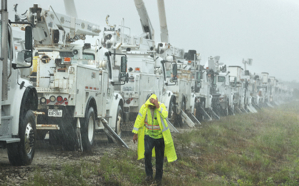
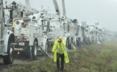
Power outages have grown throughout the day across the state, with more than 630,000 customers out by 9:30 p.m., according to poweroutage.us.
At least one fatality may end up being blamed on the storm, according to Spectrum Bay News in Tampa, which reported a fatal wreck on Interstate 4 was being investigated after traffic cameras showed what looked like an overhead sign had fallen on a vehicle.
From Fort Myers Beach up to Tampa Bay, surge from the hurricane kicked up through the afternoon into the evening flooded roads and shut down bridges. Several barrier islands are impassable now, with law enforcement saying they can no longer respond to distress calls of anyone who chose not to evacuate.
Gov. Ron DeSantis gave a press conference before 6 p.m. from the State Emergency Operations Center in Tallahassee with a status update.
He says landfall is expected closer to Taylor County east of Tallahassee around 11 p.m.
“We’re going to see some effect soon, but right now you actually still have time to be able to evacuate,” he said about residents in North Florida in the storm’s path. However, he said that time has passed for those down the Gulf Coast such as the Tampa area.
Damage will be significant in North Florida, he said.
“You have 125 mph maximum sustained right now, probably is going to be higher, whether it hits as a Category 3, Category 4, it’s going to be a significant storm,” he said. “And even as it moves inland throughout northern Florida, you are going to see trees that are going to be falling down. That’s just the reality of what we’re doing, of what we’re seeing here, and if you hear the tree limbs snapping around you, sometimes it almost sounds like fireworks are going off, treat that as a tornado, shelter in a part of the home that would be where you have protection from that.”
He said avoid standing water, don’t drive through flooded streets and don’t go outside when it’s dark out.
“There’s going to be hazards there. It’s just not something you want to be navigating in the dark,” he said.
And if it gets suddenly quiet in the middle of the storm, that’s likely the eye of the storm. Don’t go outside then, either.
After the storm, there could be downed power lines. And those using generators need to keep them safely away from their homes to avoid death from carbon monoxide poisoning.
“We can’t control how strong this hurricane is going to get. We can’t control the track of the hurricane,” DeSantis said. “But what you can control is what you can do to put yourself in the best chance to be able to ride this out in a way that’s going to be safe.”
The National Weather Service also issued a tornado watch covering the majority of Florida’s peninsula from north-central Florida down to the Keys until 8 p.m. and North Florida until 10 p.m. It expanded the watch for Central Florida and north into Georgia until 6 a.m.
Wind gusts over 60 mph forced the Florida Highway Patrol to shut down the Sunshine Skyway Bridge across Tampa Bay in the afternoon, and later shut down the Howard Frankland Bridge, Courtney Campbell Causeway and Gandy Bridge that connect Tampa to St. Petersburg.
Brennan warned of powerful winds north of landfall up into the Tallahassee area and even farther into Georgia.
“Everybody in that region needs to be prepared for hurricane-force winds, the potential for long-duration, widespread power outages, structural damage, tree damage, trees falling on homes, out on cars or people if you’re outside, and the potential for catastrophic wind damage near where the core of Helene makes landfall on the Florida Big Bend coast,” he said.
“Storm surge, wind, and rainfall impacts will extend well away from the center and outside the forecast cone, particularly on the east side,” Beven said. “In addition, the fast forward speed when Helene moves inland will result in a far inland penetration of strong winds over parts of the southeastern United States, including strong gusts over higher terrain of the southern Appalachians. … A higher-than-normal gust factor is indicated in the official forecast while Helene is inland.”
DeSantis also spoke at a 9 a.m. press conference from the state EOC in Tallahassee.
“This is a very large storm, so you’re going to see tropical weather that’s going to extend hundreds of miles away from the center of the storm,” he said.
But even though landfall will be in North Florida, Gulf Coast cities including Sarasota and Tampa are not out of danger.
“Because it’s such a big storm, it’s churning a lot of water, and so you’re going to see surge all up and down the west coast of Florida,” he said. “The water is going to rise, and that is going to create hazards as well. So just because you’re outside the cone, and I think a lot of those parts on the west coast of Florida are probably outside the cone, that does not mean that you’re not going to see significant impacts.”
The Florida Division of Emergency Management has been responding to 1,100 requests from counties with provision of requests such as generators and high-water vehicles.
Also, the state will have 30,000 linemen staged to respond to expected power outages after the storm passes.
“On the forecast track, Helene will move across the eastern Gulf of Mexico today and cross the Florida Big Bend coast this evening or early Friday morning,” Beven said. “After landfall, Helene is expected to turn northwestward and slow down over the Tennessee Valley on Friday and Saturday.”
Helene is forecast to drop 6-12 inches of rain, with some areas getting up to 18 inches across the southeast United States.
“This rainfall will likely result in areas of considerable flash and urban flooding, with areas of significant river flooding,” forecasters said. “Landslides are possible in areas of steep terrain in the southern Appalachians.”
Inland tropical storm watches are in place deep into the U.S. up into Georgia including Atlanta as well as western South Carolina and western North Carolina.
“We don’t normally issue tropical storm watches this far inland, especially here, over the Appalachians area,” Rhome said. “So that’s unusual. You really need to be paying attention. There’s also a big flood threat.”
DeSantis urged residents to listen to local evacuation orders, and avoid the tragedy seen in 2022’s Hurricane Ian that killed 149 people in Florida, most of whom were caught in major storm surge in southwest Florida.
“The field is so big with the winds and it’s going to churn up a lot of surge that you’re likely to see something significant, particularly in the barrier islands and those low lying areas,” he said. “So we always say you can hide from the wind, especially with Florida structures that have been built in modern times, but you run from the water, because if that water really does come crashing in, it’s not a lot you can do about it at that point.”
Each county has designated shelters, including at least one that will let residents take their pets.
“You don’t have to get in your car and drive 350 miles away. You can evacuate safely to higher ground,” he said. “There’s shelters, there’s hotels, friends’ houses, family. All that is fine.”
People, including some in mobile or manufactured homes, can find out if they are under an evacuation order at floridadisaster.org.
DeSantis earlier this week issued a pair of state of emergency orders covering 61 of Florida’s 67 counties. President Biden approved federal disaster assistance that authorizes FEMA to coordinate all disaster relief efforts for 28 of those counties. DeSantis said he would revisit their request to see if the federal order can be expanded, which would help refund preparations some of the cities and counties in affected areas have to make.
He said the state has SpaceX Starlink internet hardware available to deploy if needed to targeted areas along with tarps, generators and other post-landfall needs.
The state deployed for the first time this year during Hurricane Debby, which also targeted the Big Bend, new flood protection devices primarily for use to protect utility substations. DeSantis intends to deploy those again, which help get the power back up that much quicker.
There are 3,500 Florida National Guard soldiers ready to assist with post-storm assistance, which can be surged to 5,500 if necessary. The state has also mobilized more than 250 from the Florida State Guard as well as personnel from the Florida Fish and Wildlife Commission, Florida Department of Law Enforcement, county sheriffs and city police forces.
Kevin Guthrie, director of the Florida Division of Emergency Management, said he has already had 750 resource requests in from various counties.
Only the westernmost Panhandle counties have escaped any sort of watch or warning because of Helene.
More rainfall for the Florida peninsula could follow over the weekend after the system has passed through, which is a flooding concern with ground that may have just been deeply saturated already, he said.
The NHC was tracking two more systems in the Atlantic basin with a chance to become a tropical depression or storm.
As of the NHC’s 8 p.m. tropical outlook Thursday, the most likely was a broad low-pressure system associated with a tropical wave located several hundred miles west of the Cape Verde Islands has been producing more organized shower and thunderstorm activity.
“Recent satellite imagery suggests the system does not yet have a well-defined surface circulation,” forecasters said. “However, environmental conditions are expected to be conducive for further development. A tropical depression is expected to form tonight or on Friday while the disturbance moves generally westward to west-northwestward at 10 to 15 mph.”
It’s forecast to slow down and turn north-northwestward late Friday and Saturday, and is no threat to land.
The NHC gives it a 90% chance to develop in the next two days and 90% in the next seven.
The next name on the 2024 Atlantic hurricane season list is Joyce.
New on Thursday, the NHC began forecasting an area of low pressure to form over the western Caribbean by the middle of next week.
“Environmental conditions are expected to be conducive for slow development thereafter, while the system moves generally northwestward,” forecasters said.
The NHC gives it a 20% chance of development in the next seven days.
Hurricane season runs from June 1-Nov. 30, with the height of hurricane development running from mid-August into October.
_____
©2024 Orlando Sentinel. Visit at orlandosentinel.com. Distributed by Tribune Content Agency, LLC.


Comments