Tropical Storm Helene forms, forecast to hit Florida as major hurricane
Published in News & Features
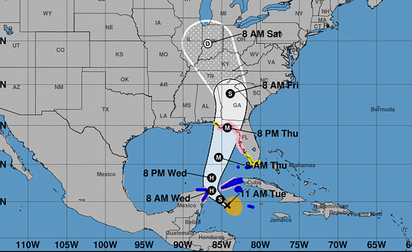
ORLANDO, Fla. — Tropical Storm Helene formed Tuesday morning in the Caribbean, and the National Hurricane Center forecasts it to move north and strike Florida as a major Category 3 hurricane on Thursday night.
Earlier Tuesday, the NHC issued hurricane watches for Florida’s Gulf Coast and warned storm surge could reach as high as 15 feet near its expected landfall targeting the Big Bend region.
In its 2 p.m. EDT advisory, the system’s center was located in the northwest Caribbean Sea about 175 miles east-southeast of Cozumel, Mexico and 175 miles south of the western tip of Cuba with maximum sustained winds of 45 mph as it moved west-northwest at 12 mph.
Tropical-storm-force winds extend out 140 miles from its center.
Forecasters predict it will become a hurricane by Wednesday in the Gulf of Mexico and then rapidly intensify into Thursday as it moves across the eastern Gulf of Mexico.
“It is going to be a big storm, and by big I mean not intensity, I mean size,” said NHC Deputy Director Jaime Rhome on Tuesday. “And big storms cause big problems. And that’s one of the take-home messages that I need you to understand.”
The NHC’s projection has it growing to a Category 3 hurricane with 115 mph winds and 140 mph gusts with landfall Thursday night.
He noted tropical storm warnings and watches extending basically from the Florida Keys all the way around to the Panhandle with inland watches including most of Central Florida.
“The wind swath is going to be huge with this system, and it’s basically going to carve a path right over a good portion of the Florida peninsula, including the highly populated I-4 corridor,” he said. “So if you’re watching from Tampa and Orlando, you’re going to have a big wind event with this, no matter where it goes with respect to the track.”
The storm’s center has a likely target of the Big Bend, similar to this year’s Hurricane Debby and 2023’s Hurricane Idalia, but could also still shift to the east near Tampa or west to the middle of Florida’s Panhandle.
“All indications are a significant hurricane impacting the Florida Big Bend, but, and this is a big but, the hazards are going to be well removed from the center and well removed from the cone,” Rhome said. “So I don’t want you to look at the cone and say, ‘I’m out of the cone,’ or ‘I’m on the edge of the cone,’ because this wind field, the wind field with this system, is going to be really large — larger than you’re used to seeing with a traditional hurricane.”
By 11 a.m., the NHC had issued a tropical storm warning for the lower Florida Keys west of the Seven Mile Bridge and the Dry Tortugas and added a tropical storm watch for the middle Florida Keys from the Seven Mile Bridge to the Channel 5 Bridge.
Earlier, the NHC had issued a hurricane watch on Florida’s Gulf Coast from Englewood north to Indian Pass including Tampa Bay while a tropical storm watch was in effect from Englewood south to Flamingo, and from Indian Pass west to the Walton-Bay county line.
A storm surge watch is in effect from Indian Pass south to Flamingo, Tampa Bay and Charlotte Harbor.
“It’s going to push a big swath of storm surge across the western portions of the Florida peninsula,” he said. “This area is really, really vulnerable to storm surge. It’s not going to take a lot of wind, and even tropical-storm-force winds along the Florida West Coast produce significant and life threatening storm surge.”
The NHC warned surge and high tide could lead to 10-15 feet above normal from the Ochlockonee River to Chassahowitzka, from 6-10 feet from Chassahowitzka to the Anclote River, 5-10 feet from Indian Pass to the Ochlockonee River, 5-8 feet from the Anclote River to the middle of Longboat Key and Tampa Bay, 4-7 feet from the middle of Longboat Key to Englewood, and 3-5 feet from Englewood to Bonita Beach and Charlotte Harbor.
Gov. Ron DeSantis issued a state of emergency order Monday for 41 of Florida’s 67 counties, and increased that to 61 on Tuesday. He said during a press conference Tuesday morning that the state also asked for pre-landfall declaration from FEMA.
He said the NHC has never in its history had a forecast for a major hurricane for a system that had yet to even form, which was the case when it was just Potential Tropical Cyclone Nine earlier Tuesday.
“I think it’s because there’s some similarities to the track that was taken (by 2018’s Category 5) Hurricane Michael, and I think the thought is that when it’s over the Gulf, especially the more north it goes, rather than east, it has a chance to have a rapid intensification,” DeSantis said. “So we, as always, we prepare for the worst, we hope for the best, but we’d rather be prepared and then have it not reach that level, than just hope that it doesn’t intensify and then be caught not being prepared.”
He said Florida residents still have time Tuesday and early Wednesday to prepare, fill gas tanks, get water and nonperishable food, clean up yards for potential debris and know evacuation zones.
“Right now, regardless of how it forms or the speed right now, you do have time, so take advantage of that time,” he said.
He said more than 18,000 utility linemen are prepped to respond to expected power outages from the hurricane. He also said the state has SpaceX Starlink internet hardware available to deploy if needed to targeted areas. And just as the state deployed in this year’s Hurricane Debby, which also targeted the Big Bend, the state has new flood protection devices primarily for use to protect utility substations.
There are 3,000 Florida National Guard soldiers ready to assist with post-storm assistance as well as Florida State Guard, Florida Fish and Wildlife Commission and county sheriff’s office personnel.
“These resources are being added by the minute, so you’re going to continue to have more linemen brought in. You’re going to continue to have more beef added to these staging areas,” DeSantis said. “We’ll continue to watch the forecast, watch how this develops, see what the time frame is going to be, but we’re going to get something that’s for sure.”
Kevin Guthrie, director of the Florida Division of Emergency Management, said the state expanded its county disaster declaration because of the expected size of the storm.
“This hurricane will have tropical-storm-force winds in excess of 250 miles from the center,” Guthrie said. “That will encompass most of the peninsula from the Space Coast all the way through the First Coast and then on the west coast of Florida, the entire coastal portion of the west coast of Florida.”
DeSantis urged residents to listen to local evacuation orders, and avoid the tragedy seen in 2022’s Hurricane Ian that killed 149 people in Florida, most of whom were caught in major storm surge in southwest Florida. He said evacuation doesn’t have to be far, but they do need to get out from the danger zone.
“Most of the evacuations from the low lying areas, people do not need to even leave their county. In most instances, it’s just getting away from when that water comes, and then as soon as the storm passes, you go out, and hopefully you don’t have major damage,” he said. “But the reality is that water, when you’re there, that’s tough. The wind you can hide from. Anything that’s shelter in Florida is going to be able to withstand the wind, but it’s the water that can be really, really devastating if you remain there when you’re told to evacuate.”
Its immediate threat in the Caribbean also means a hurricane watch is in effect for Cabo Catoche to Tulum, Mexico and the Cuban province of Pinar del Rio with a tropical storm warning in place for Rio Lagartos to Tulum, Mexico and the Cuban provinces of Artemisa, and Pinar del Rio, and the Isle of Youth.
Rain over western Cuba and the Cayman Islands could see as much as 12 inches in some places with as much as 6 inches over the eastern Yucatan Peninsula with a risk of flash and urban flooding and minor river flooding. Storm surge up to 4 feet is a threat for parts of Cuba and Mexico.
For Florida, the potential for heavy rains and increased winds is increasing from Wednesday night through Friday.
The NHC said 4-8 inches with some areas getting 12 inches could fall in parts of Florida and the southeastern United States.
In Central Florida, a tropical storm watch is in effect inland for Lake, Marion, Orange, Osceola, Polk, Seminole and Sumter counties.
National Weather Service Melbourne meteorologist Scott Kelly said the storm looks to have a large wind field once it matures extending far to the east of its center.
“While it is too early to describe specific impacts for east Central Florida, heavy rainfall and tropical-storm-force winds are becoming anincreasing concern,” Kelly said. “A few tornadoes will also be possible in the rainbands.”
More rainfall for the Florida peninsula could follow over the weekend after the system has passed through, which is a flooding concern with ground that may have just been deeply saturated already, he said.
The NHC predicts tropical-storm-force winds could arrive to South Florida by 8 a.m. Wednesday and into Central Florida by 8 p.m.
The NHC was tracking a second system in the eastern Atlantic also has a high chance to develop into a tropical depression or storm.
As of the NHC’s 2 p.m. tropical outlook, the tropical wave located west of the Cape Verde Islands and was producing more concentrated shower and thunderstorm activity since Monday.
“Environmental conditions appear favorable for gradual development of this system, and a tropical depression is likely to form in a few days while it moves westward to west-northwestward across the eastern and central tropical Atlantic,” forecasters said.
The NHC gives it a 40% chance to develop in the next two days and 80% in the next seven.
The next name on the 2024 Atlantic hurricane season list is Isaac.
Hurricane season runs from June 1-Nov. 30, with the height of hurricane development running from mid-August into October.
-------
©2024 Orlando Sentinel. Visit at orlandosentinel.com. Distributed by Tribune Content Agency, LLC.


Comments